| Home | Testimonials | Portfolio | Suggestions | Brochure | Prices | Request Info | Privacy |


Website Design
“Small Towne” Convenience, Dedication
Affordability, and Personal Attention
Serving the Petrolia and Sarnia area since 2006
519-882-1809 / 519-331-0927


Drone Applications
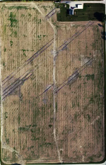
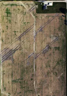
Although this was not a commercial job, a friend asked if I could help him determine if newly installed field tile had corrected a
drainage problem on his 30 acre farm. The first image shows a satellite image of his field from a time before the tile was installed.
Note the troublesome wet area at the middle left area of the field.
Using a surface mapping application to control the drone, a series of images were obtained while autonomously flying a pattern
above the field. The pattern was programmed to ignore the house and garage at the top right in the image. The flight took less
than 15 minutes.
Play the video to see the pattern that the drone flew while a total of 48 pictures were taken looking down on the field. Stitching
software then blended all the
images together and the
result was the composite
image.
Ignoring the diagonal tire
marks, one can see the rows
of tile which run vertically the
length of the field, connected
at each end. The wet area
appears dry now. The image
serves as a permanent record
of tile location.
In Spring, the process could
be used to determine if tiles
are working or plugged.
During the growing season,
the process could show the
relative growth of crops in the
field, perhaps indicating what
areas require more or less
fertilizer.
Although no video was
recorded for this project, it
would have provided a nice
tour of the farm.


Agricultural - Field Mapping:


Composite Drone Image Showing Tile
Location and drained problem area
Satellite image of field showing wet
problem area at left center


Website
Design


“Small Towne” Convenience, Dedication
Affordability, and Personal Attention

519-882-1809 / 519-331-0927
| Home | Testimonials | Portfolio | Suggestions | Brochure |
| Prices | Request Info | Privacy |
Although this was not a commercial job, a
friend asked if I could help him determine if
newly installed field tile had corrected a
drainage problem on his 30 acre farm. The
first image shows a satellite image of his field from a time before
the tile was installed. Note the troublesome wet area at the
middle left area of the field.
Using a surface mapping application to control the drone, a
series of images were obtained while autonomously flying a
pattern above the field. The pattern was programmed to ignore
the house and garage at the top right in the image. The flight
took less than 15 minutes.
Play the video to see the pattern that the drone flew while a total
of 48 pictures were taken looking down on the field. Stitching
software then blended all the images together and the result
was the composite image.
Ignoring the diagonal tire marks, one can see the rows of tile
which run vertically the length of the field, connected at each
end. The wet area appears dry now. The image serves as a
permanent record of tile location.
In Spring, the process could be used to determine if tiles are
working or plugged. During the growing season, the process
could show the relative growth of crops in the field, perhaps
indicating what areas require more or less fertilizer.
Although no video was recorded for this project, it would have
provided a nice tour of the farm.
Drone Applications
Agricultural - Field Mapping:
Satellite image of field
showing wet problem area
at left center
Composite Drone Image
Showing Tile Location and
drained problem area


Website
Design
Serving the Petrolia
and Sarnia area
since 2006


519-882-1809 / 519-331-0927


“Small Towne” Convenience, Dedication
Affordability, and Personal Attention

Although this was not
a commercial job, a
friend asked if I could
help him determine if
newly installed field tile had corrected a
drainage problem on his 30 acre farm. The
first image shows a satellite image of his
field from a time before the tile was
installed. Note the troublesome wet area at
the middle left area of the field.
Using a surface mapping application to
control the drone, a series of images were
obtained while autonomously flying a
pattern above the field. The pattern was
programmed to ignore the house and
garage at the top right in the image. The
flight took less than 15 minutes.
Play the video to see the pattern that the
drone flew while a total of 48 pictures were
taken looking down on the field. Stitching
software then blended all the images
together and the result was the composite
image.
Ignoring the diagonal tire marks, one can
see the rows of tile which run vertically the
length of the field, connected at each end.
The wet area appears dry now. The image
serves as a permanent record of tile
location.
In Spring, the process could be used to
determine if tiles are working or plugged.
During the growing season, the process
could show the relative growth of crops in
the field, perhaps indicating what areas
require more or less fertilizer.
Although no video was recorded for this
project, it would have provided a nice tour
of the farm.
Drone Applications
Agricultural - Field Mapping:

Satellite image of field showing wet
problem area at left center
Composite Drone Image Showing Tile
Location and drained problem area

